Engineering tomorrow through geospatial intelligence & water resources innovation
Professional consultancy in hydrological, hydraulic and urban flood modeling with OpenLISEM and HEC-RAS, GIS, remote sensing, drought analysis and geospatial software — data-driven, scientifically sound solutions for governments, engineering firms, NGOs and researchers worldwide.
- Hydrology
- Hydraulics
- Urban Flood
- GIS
- Remote Sensing
- Drought
- Web GIS
Flood depth (m)
- Projects Delivered
- 120+
- Countries Served
- 14+
- Sq. Km Analyzed
- 850,000+
- Years of Combined Expertise
- 15+
Methodology aligned with
- WMO Hydrological Guidelines
- FEMA Flood Mapping Standards
- USACE HEC Modeling Protocols
- ISO 19115 Geospatial Metadata
- OGC Open Standards
- IWRM Principles
A multidisciplinary consultancy built at the intersection of water science and geospatial technology.
GeoVeris was founded to close the gap between advanced environmental modeling and the decision-makers who need it most. We work directly with government departments, municipal authorities, engineering firms, NGOs, and research institutions to turn satellite imagery, hydrological data, and terrain models into infrastructure that survives the next flood, the next drought, and the next decade of climate change.
Mission-Driven
We exist to help institutions make better decisions about water, land, and infrastructure using rigorous, defensible science.
Multidisciplinary
Hydrologists, hydraulic engineers, GIS analysts, remote sensing scientists, and software engineers working as one integrated team.
Technology-Forward
From HEC-RAS 2D to Google Earth Engine to modern web platforms — we build with the tools that produce the most reliable, reproducible results.
Nine disciplines. One integrated engineering partner.
From basin-scale hydrology to production GIS software, our team delivers the full analytical and technical stack behind resilient water and land-use decisions.
Hydrological Modeling
Rainfall-runoff and watershed-scale modeling to quantify water availability, flood potential, and basin response under current and future climate conditions.
- Rainfall-Runoff Modeling
- Watershed Modeling
- HEC-HMS
- SWAT
Hydraulic Modeling
1D and 2D river hydraulics, floodplain mapping, and structure analysis using HEC-RAS — from bridge scour studies to basin-wide inundation mapping.
- HEC-RAS 1D
- HEC-RAS 2D
- River Hydraulics
Urban Flood Modeling
Pluvial and combined-sewer flood risk modeling for cities using OpenLISEM, HEC-RAS 2D, and EPA SWMM — built for planners, not just engineers.
- OpenLISEM
- HEC-RAS 2D
- EPA SWMM
GIS & Geospatial Analysis
Spatial analysis, terrain modeling, geoprocessing automation, and spatial data infrastructure — the analytical backbone behind every engineering decision we support.
- Spatial Analysis
- Terrain Analysis
- DEM Processing
Remote Sensing & Satellite Image Analysis
Multispectral and radar satellite image analysis for land cover mapping, change detection, and environmental monitoring at regional to national scale.
- Sentinel & Landsat Processing
- MODIS Time Series
- Planet Imagery
Drought Analysis
Meteorological, agricultural, and hydrological drought monitoring using SPI, SPEI, and satellite-derived vegetation and water indices.
- Meteorological Drought Monitoring
- Agricultural Drought Assessment
- Hydrological Drought Analysis
From raw data to defensible decisions
A structured methodology with clear milestones — you always know what's been analyzed, what's next, and why it matters.
- 01
Scope & data audit
We define the decision the work must support, then inventory rainfall, discharge, terrain, land-use and imagery — and close the gaps before modeling starts.
- Inception report
- Data gap register
- 02
Model & analyse
Hydrology, hydraulics, remote sensing and GIS built as one chain, using the tool the problem calls for — HEC-HMS, HEC-RAS 2D, OpenLISEM, SWAT, Earth Engine.
- Model build
- Scenario runs
- 03
Calibrate & validate
Every model is calibrated against observed data, validated on an independent period and documented so it survives peer review and regulatory scrutiny.
- Calibration statistics
- Sensitivity analysis
- 04
Deliver & transfer
Decision-ready maps, dashboards and reports — plus training so your team can run, update and defend the models after we hand them over.
- Maps & dashboards
- Capacity building
Trusted across the public and private sectors
Our clients share one thing in common: decisions with real consequences for people, land, and water.
Public Sector
6 sectorsPrivate & Industrial
6 sectorsResearch & Development
2 sectorsNGOs & International
2 sectorsEngineering credibility. Geospatial precision.
We combine the technical depth of a specialist consultancy with the delivery discipline of a modern technology firm.
Scientifically Rigorous
Every model is calibrated, validated, and documented to withstand peer review, regulatory scrutiny, and donor audit.
International Experience
Engagements spanning river basins, coastal cities, and arid regions across 14+ countries and multiple climate zones.
Fast, Transparent Delivery
Structured methodology with clear milestones — you always know what's been analyzed, what's next, and why it matters.
Defensible & Auditable
Reports built to survive scrutiny from regulators, funding bodies, and technical review panels.
Capacity Building Included
We transfer skills, not just deliverables — training your team on the same tools and workflows we use.
Decision-Ready Outputs
Interactive dashboards and geospatial tools designed for planners and executives, not just technical staff.
Selected projects, real outcomes
Flood hazard, drought and hydrological studies delivered for real basins and cities — with the models and maps to show for it.
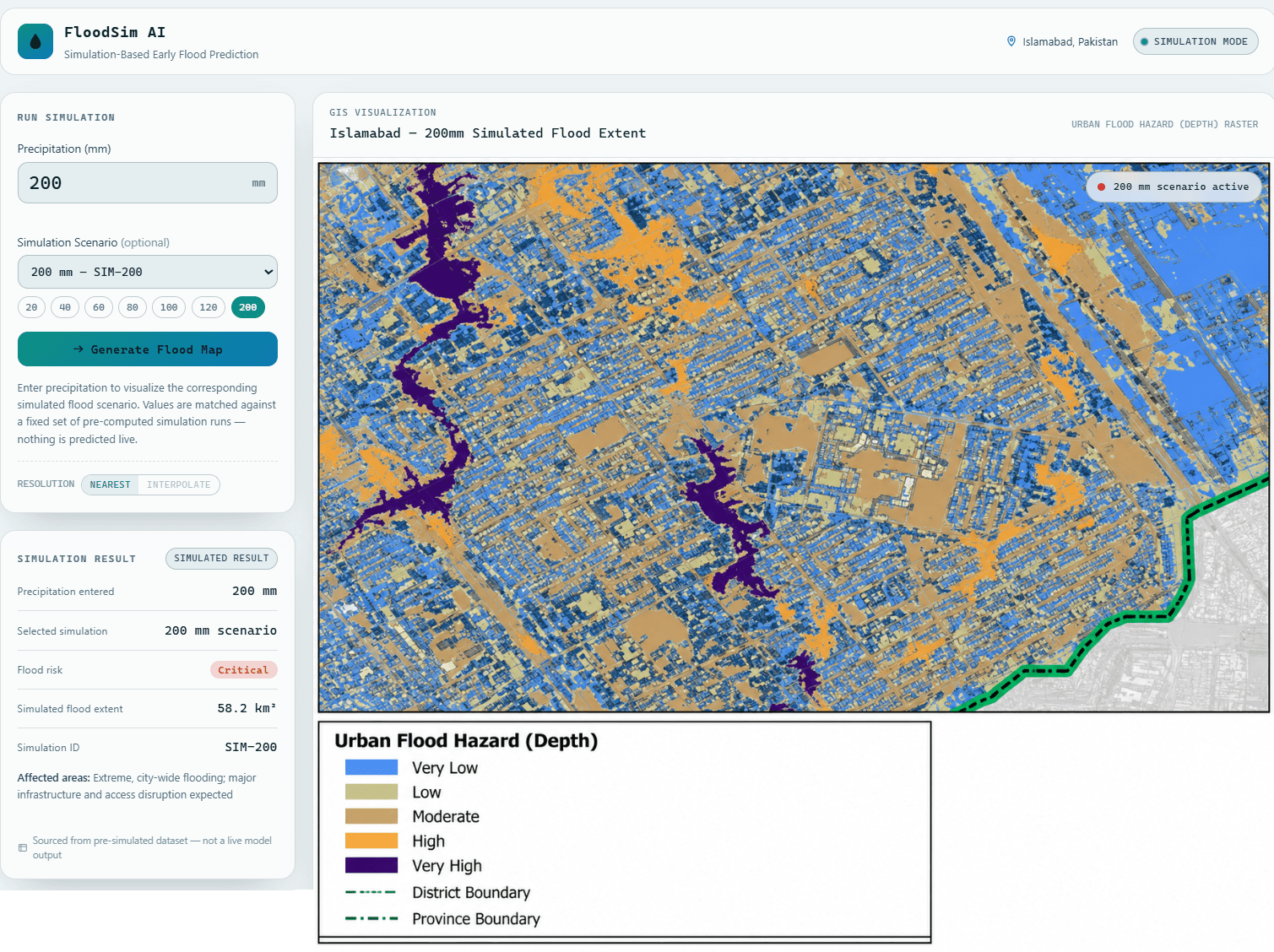
FloodSim AI
A simulation-based early flood prediction dashboard for Islamabad, Pakistan — visualizes pre-computed flood-hazard scenarios by precipitation total.
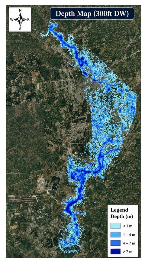
Kalpani Nullah 2D Hydraulic Flood Hazard Modeling
HEC-RAS 2D depth and velocity modeling of an urban hill-torrent nullah running through Mardan, mapping flood hazard for the 300 ft design flood to guide drainage and mitigation planning.
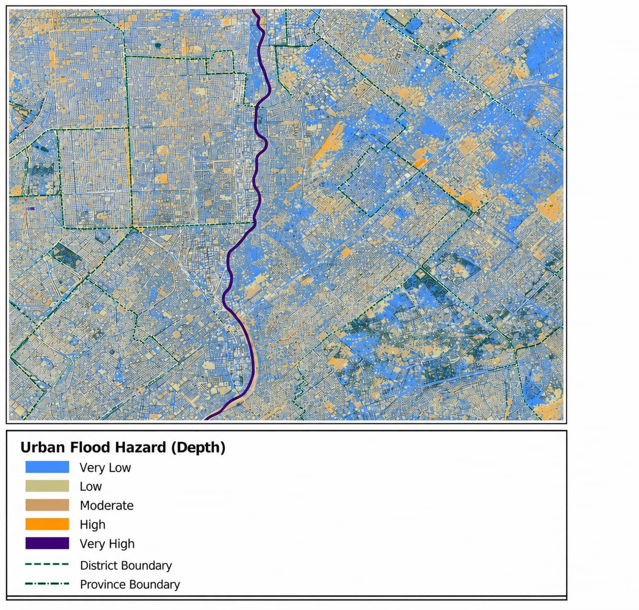
Karachi Urban Flood Hazard Modeling (openLISEM)
An event-based urban flood hazard simulation in openLISEM, classifying inundation depth across a built-up Karachi district and the watercourse running through it.
Built on industry-standard, defensible tools
The same software regulators, lenders and review panels already trust — so results can be checked, reproduced and handed over.
Hydrology & Hydraulics
- HEC-HMS01
- HEC-RAS 1D/2D02
- SWAT03
- EPA SWMM04
- OpenLISEM05
GIS & Remote Sensing
- ArcGIS Pro01
- ArcGIS Enterprise02
- QGIS03
- Google Earth Engine04
- ERDAS Imagine05
Satellite & Imagery
- Sentinel-1/201
- Landsat 8/902
- MODIS03
- Planet Imagery04
- SRTM / DEM05
Development & Automation
- Python01
- ArcPy02
- PyQGIS03
- Next.js / React04
- PostgreSQL / PostGIS05
What our clients say
“GeoVeris delivered a basin-wide flood hazard map that our field teams actually use during monsoon season — not just a report that sits on a shelf.”
“The custom ArcPy toolbox they built cut our quarterly land-use reporting from three weeks to two days. It just works, and our team can maintain it ourselves.”
“Their HEC-RAS 2D flood model gave us the confidence to finalize our embankment design six weeks ahead of schedule. The documentation alone saved our review board weeks of back-and-forth.”
Frequently asked questions
How engagements work, who we work with and what we deliver — the questions clients ask before the first call.
Still have a question?
Talk to an engineer — we reply within one business day.
GeoVeris is a multidisciplinary engineering consultancy specializing in hydrological and hydraulic modeling, urban flood modeling, GIS, remote sensing, drought analysis, and full-stack web/GIS software development. We work with governments, municipalities, NGOs, engineering firms, and research institutions worldwide.
Let's discuss your project
Whether you need a full feasibility study or a second opinion on an existing model, our team responds within one business day.
Send us a message
Routed to the right specialist, not a sales queue.
- Emailinfo@geoveris.tech
- Phone03474229299
- Office HoursMonday – Friday, 9:00 AM – 6:00 PM (local time)
- AddressIslamabad, Pakistan
Connect with GeoVeris
Engineering insights, geospatial research, project updates and field notes on water, land and infrastructure — straight to your inbox. No spam, unsubscribe anytime.
Get the newsletter
Follow us
- LinkedInSoon
- YouTubeSoon
- InstagramSoon
- XSoon
- FacebookSoon