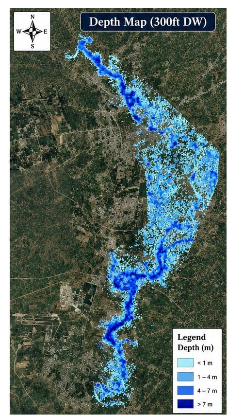
Kalpani Nullah is a seasonal hill torrent that runs directly through the built-up core of Mardan, and the municipal drainage authority responsible for the corridor had no depth- or velocity-classified hazard map to work from — only a general sense of which reaches flooded worst in past events. Any drainage upgrade or encroachment decision was being made without a quantified picture of how deep, and how fast, floodwater actually moves through the corridor.
GeoVeris built a 2D unsteady HEC-RAS model of the nullah using DEM/TIN terrain data and land-use-based Manning's roughness, georeferenced to WGS 84 / UTM Zone 43N, and ran it for the 300 ft design flood condition to produce classified depth and velocity distribution maps across the full corridor.
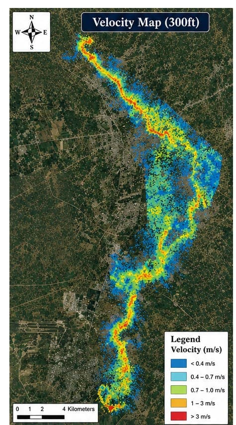
The output gave the authority its first hazard map with standard depth bins (under 1 m through over 7 m) and velocity bins (under 0.4 m/s through over 3 m/s), distinguishing the high-velocity, erosion-prone main channel from the shallower, slower floodplain ponding around it.
The maps are now the authority's working reference for flood risk assessment, stormwater drainage planning, and infrastructure protection along the corridor.
Methodology
Modeled flow depth and velocity distribution along the Kalpani Nullah corridor in HEC-RAS 2D for the 300 ft design flood (DW), using DEM/TIN terrain data and land-use-based Manning's roughness coefficients, georeferenced to WGS 84 / UTM Zone 43N. Classified outputs into standard depth bins (<1 m, 1-4 m, 4-7 m, >7 m) and velocity bins (<0.4, 0.4-0.7, 0.7-1.0, 1-3, >3 m/s) to produce a hazard map usable directly by drainage planners.
Results & Outcomes
- Mapped flood depth and velocity distribution along the full modeled nullah corridor for the 300 ft design flood
- Identified maximum depths exceeding 7 m in the deep channel and low-lying floodplain areas
- Flagged velocities above 3 m/s confined to the main channel, indicating elevated erosion risk
- Hazard maps adopted to support flood risk assessment, drainage planning, and mitigation prioritization
Challenges
The nullah's flashy hill-torrent regime meant flood behavior was governed as much by channel confinement through the urbanized reach as by peak discharge alone. Land-use-based roughness zoning was used to differentiate channel and floodplain conveyance so the model could distinguish high-velocity, erosion-prone channel flow from the shallower, lower-velocity ponding typical of the surrounding built-up floodplain.